Getting clear of the city
The riding around Sydney is excellent and the first hour is the problem. The city's edges are slow in every direction, and a Saturday morning departure costs more time than the ride that follows it.
The practical answer is direction and timing rather than a clever route. South and north both have a motorway that gets you out quickly; west has the Great Western Highway, which is the slowest of the three and the one most riders take because the mountains are the reason they came.
Pick a side of the city the night before and leave early. It sounds trivial and it changes the whole day.
If the trip is a family one and the bike is staying home, a campervan hired in Sydney covers the same south coast with more room — a different trip, and a fair one for the national parks either side of the city.
- South: the M1 towards the Illawarra, then the Royal National Park or Macquarie Pass.
- North: the M1 towards the Central Coast, then the old Pacific Highway for the Hawkesbury.
- West: the Great Western Highway to the Blue Mountains, which is slow but leads to the best escarpment roads.
- North-west: Windsor and the Putty Road, the longest single run available from the city.
Royal National Park and the coast
South of Sydney, Royal National Park is the second-oldest national park in the world, established in 1879 and heritage listed, covering coastline, heath and rainforest near Cronulla and Bundeena.
It is also a park with a queuing problem. The park's own visitor information warns that roads inside it can be extremely busy, and the park is open from 7am to 8.30pm with a per-vehicle entry fee payable at the visitor centre, entry stations, machines or by app.
That fee is small and the timing matters more. An early start gets you through the good section before the car parks fill, and the coast road south past Stanwell Tops is the payoff.
- Gate hours are 7am to 8.30pm, and the park can close for fire danger or weather.
- Pay the vehicle entry fee at the visitor centre, the entry stations, the machines or by app.
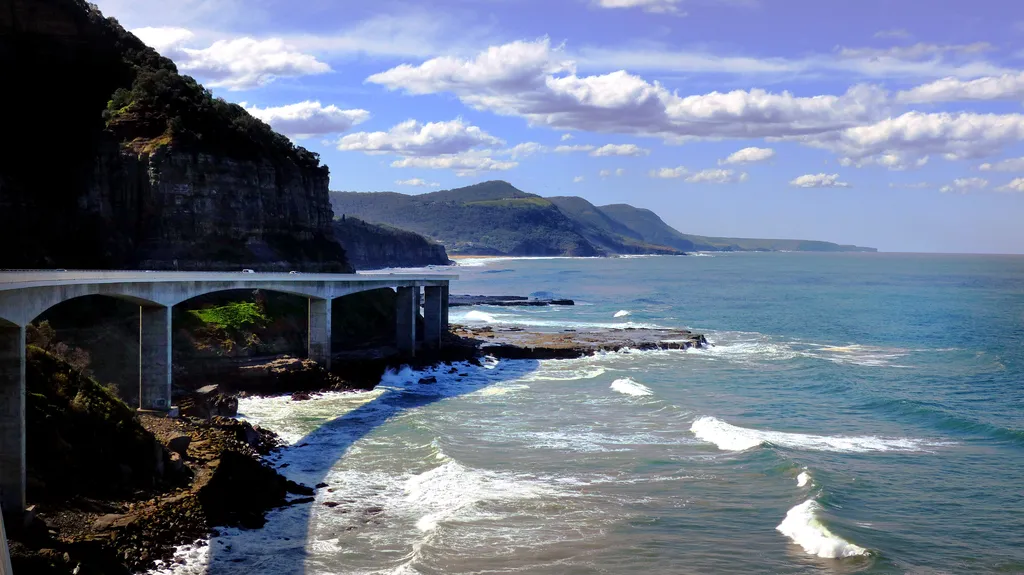
- The coast road and the Sea Cliff Bridge are the two set pieces; both are slow when busy.
- Weekday mornings are the difference between a ride and a traffic queue.
Park closures for fire danger are not rare in summer. Check the park alerts page the night before rather than assuming it will be open.
Macquarie Pass and the Illawarra escarpment
Macquarie Pass National Park sits on the Illawarra escarpment between the coastal plain and the Southern Highlands, and the pass is the link between the two: a climb out of rainforest and tall eucalypt into cooler tableland country.
The park is small and the road is the reason riders go. Cascades picnic area and the Cascades walk are the park's own highlights, a short walk through shady rainforest near Wollongong — which makes it a reasonable place to stop rather than blast through. The pass and the coast road are covered in more detail in motorcycle rides in New South Wales.
Riding it as a loop means deciding which side to climb and where to rejoin the highway. Climbing from the coast is the better direction: you gain height with the corners rather than descending into them.
- Climb from the coast side for the better gradient and the better view.
- Cascades picnic area is the natural stop, with a short rainforest walk from the car park.
- The Southern Highlands towns at the top are where the ride turns into a day out.
- Expect wet road under canopy after rain, and leaf litter on the corners in autumn.
The Blue Mountains and Bells Line
West of the city the country changes completely. Blue Mountains National Park holds well over a hundred kilometres of tracks and trails across six areas, from Glenbrook in the east to the remote southern sections, and it is within about two hours of Sydney.
The riding here is about the crossing rather than a single pass. The escarpment lookouts sit on the eastern side, the descents run out into the western plains, and Bells Line of Road is the northern alternative that riders take when the Great Western Highway is a car park.
It is high country in the ordinary sense: colder than the coast, prone to fog on the escarpment, and with weather that can close lookouts and walking tracks at short notice.
- Bells Line of Road: the northern crossing, quieter than the highway and better surfaced for riding.
- The escarpment lookouts: the reason to stop, best in the early morning before the tour buses.
- Glenbrook and the lower mountains: the eastern entry point and the busiest section.
- Fog and cold: the escarpment can be ten degrees cooler than the city and fogged in while the coast is clear.
The Putty Road
The Putty Road runs north from the Hawkesbury country through Colo towards the Hunter Valley, and it is the longest genuinely good run available from Sydney. It is a full day rather than an afternoon.
It is also a road under repair. Transport for NSW has run a repair program on it, which means stop-and-go traffic control, lane closures and reduced speed limits through the work zones in some periods. That changes a flowing road into a queue at short notice.
Check the current conditions before committing. When it is clear, it is the best long ride out of the city; when it is not, the alternative is the old Pacific Highway north.
- Windsor is the last town with full services before the run.
- Work zones and traffic control can turn it into a slow day; check before you go.
- The Hunter Valley at the northern end is where the ride becomes a weekend.
- Fuel up before Colo rather than relying on the small stops along the way.
North: the old Pacific Highway
North of Sydney, the old Pacific Highway follows the Hawkesbury River and threads through the Brisbane Water hinterland, away from the motorway that replaced it as the main route north.
Because the motorway carries the through traffic, the old road is quieter — but it is narrow and residential in places, and it passes through towns rather than around them. Ride it as a road through places rather than a highway, and it rewards the change of pace.
It also pairs naturally with the Hawkesbury: the river crossings, the ferry at Wisemans Ferry and the ridge roads behind them make a loop rather than an out-and-back.
- The Hawkesbury river section: the reason to take the old road rather than the motorway.
- Wisemans Ferry: a river crossing that turns the ride into a loop.
- The Brisbane Water hinterland: narrow, shaded and slow in the good sense.
- Watch for local traffic and driveways; this is a residential road for much of its length.
Before you leave
Sydney's riding is close enough to the city that it is easy to treat as a spur-of-the-moment thing, and that is where most of the frustration comes from. A little planning turns a frustrating exit into a good day.
The park pass is worth knowing about before Royal National Park rather than at the barrier, and the state guide covers the roads in more detail if you are building a longer trip out of the city.
- Leave early, and pick the side of the city the night before.
- Buy the park pass at the gate or in the app before you arrive at Royal National Park.
- Check park alerts for closures from fire danger, especially in summer.
- Check live traffic for the Putty Road work zones before committing to the long run.
What is worth riding to
Royal National Park
Heritage-listed coast and heath south of the city, with a per-vehicle entry fee and gate hours that decide your start time.
Macquarie Pass
The escarpment climb from the Illawarra plain to the Southern Highlands, with a short rainforest walk at Cascades.
Blue Mountains and Bells Line of Road
The northern crossing of the mountains, quieter than the highway and colder than the coast.
Putty Road
The longest good run out of Sydney, north from the Hawkesbury towards the Hunter, subject to roadworks.
Old Pacific Highway
The river road north through the Hawkesbury and Brisbane Water hinterland, narrow and quiet.
Snowy Mountains
A long day south and the start of the best high country riding in the state, best in summer.
Southern Highlands
Cooler tableland country above the escarpment, with towns spaced for a lunch stop.
Questions riders ask
What are the best day rides from Sydney?
Royal National Park and the coast road south, Macquarie Pass and the Southern Highlands, the Blue Mountains via Bells Line of Road, and the Putty Road north through the Hawkesbury country. Each is a different length of day.
Do I need to pay to ride through Royal National Park?
Yes. The park charges a per-vehicle entry fee, payable at the visitor centre, the entry stations, the machines or through the park's app, and it is open 7am to 8.30pm.
Is the Putty Road open?
It varies. Transport for NSW has run a repair program on the road with traffic control, lane closures and reduced limits in work zones, so check current conditions before committing to it.
When is the best time to ride around Sydney?
Spring and autumn. Summer brings fire danger closures and holiday traffic on the coast roads, and the mountains are cold and prone to fog in winter.
Sources
- NSW National Parks — Royal National Park — nationalparks.nsw.gov.au
- NSW National Parks — Macquarie Pass National Park(nationalparks.nsw.gov.au)
- NSW National Parks — Blue Mountains National Park(nationalparks.nsw.gov.au)